Recreation and Nature Preserve in the Rolling Hills of Coosa County
By Kenny Johnson, ADCNR
 The Forever Wild Coosa Wildlife Management Area (WMA) Cahaba and Columbiana Tract consists of 9,746 acres of mountain longleaf pine and hardwood habitat with-in the Weogufka and Hatchet Creek watersheds in Coosa County. This acreage contributes to the 32,624 total acres within the Coosa WMA, one of Alabama’s oldest established public hunting areas. The Forever Wild Land Trust section of the Coosa WMA provides recreational opportunities including hunting, fishing, canoeing, hiking and camping.
NEW TRAIL AND CAMPSITES
The Alabama State Lands Division recently opened an 11.4-mile thru-hike trail on the Forever Wild Coosa WMA tract. The trail meanders along WMA roads and through the forest providing occasional scenic views of Mitchell Lake and Hatchet Creek. The hiking trail is free to use and open year-round.
Trailheads and parking areas are conveniently located on either end of the trial.
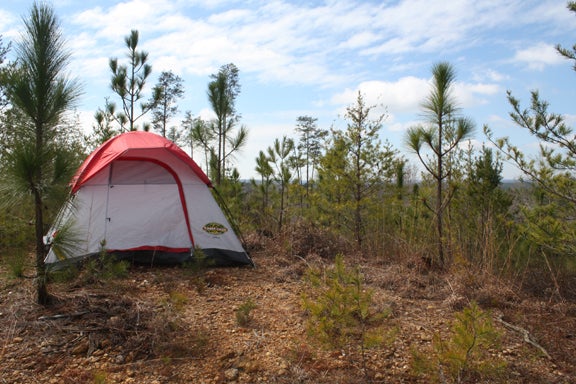
Two primitive campsites accommodating eight to 10 campers each are available along the trail. The west-end campsite is located just off the trailhead. The second camp- site is located at the trail’s midpoint. Each site is only accessible via hike-in. There are currently no fi e rings, but campfires are allowed. Camping is free with no registration necessary. Campers should leave the site clean and make sure any cooking or campfires are completely out before leaving the area.
Kent Cooper of Weogufka, Ala. is an avid hunter, angler and hiker. He is also a member of the Alabama Hiking Trail Society (AHTS). The AHTS plans, builds, and maintains hiking trails throughout the state. Together with a work crew from the State Lands Division, the AHTS helped design and build the Coosa WMA Trail. Cooper has hunted and explored the Coosa WMA for years and was instrumental in the routing of the trail. Working with State Lands, Cooper drew out the original route. That path would later be adjust- ed on the east end due to timber cutting and the replanting of longleaf pine.
“The original route was chosen as a result of me hunting the Coosa WMA for so long,” Cooper said. “I was familiar with the terrain and chose the path I thought would provide the best hiking experience.”
Cooper drew the route on topographic maps of the Coosa WMA. He gave those maps to State Lands, which finished the trail routing process.
The AHTS hopes to eventually take the Coosa trail to Flagg Mountain, the future terminus of the Pinhoti National Recreation Trail. The group’s long-term vision of a Coosa- Pinhoti connector will rely heavily on volunteers, landowners, and partnerships with various local governments. The potential path of the connector could follow roads and hiking trails established by the Civilian Conservation Corp in the 1930s.
If that connector is realized, a hiker could take the Coosa trail to the Appalachian National Scenic Trail (AT) in north Georgia.
“Our vision includes connecting the Pinhoti to Flagg Mountain,” Cooper said. “The Coosa trail would then connect Flagg Mountain to Mitchell Dam. We also hope to connect the Coosa trail to the Alabama Trail when it runs through the Oakmulgee District of the Talladega Nation Forest.”
The Alabama Trail is a long-term project to create a hiking trail from Mobile to Florence — more than 550 miles. The Alabama Trail will also create a wilderness corridor/ greenway offering wildlife a natural migration path. The Alabama Trail will offer day hiking and overnight camping, and provide ecotourism dollars for the state and local communities.
“With all of the recent trail-building activity going on in the state, we hope to make Alabama a worldwide hiking destination,” Cooper said.
The Coosa WMA trail is predominantly moderate with a few semi-strenuous climbs. The west-end of the trail is not as steep, while the east-section offers more climbs and switchbacks. Originally blazed in red, the trail has recently been re-blazed in yellow. If you’re not up for the entire 11.4 miles, Cooper recommends hiking his favorite section – the western half of the trail.
WILDLIFE
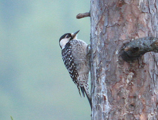
The Forever Wild Coosa WMA addition is also a nature preserve and home to a small population of red-cockaded woodpeckers (RCW). The cardinal-sized RCW, which sports distinctive black and white horizontal stripes and large white cheek patches, is currently listed as an endangered species. The RCW’s proclivity for old growth, longleaf pine is what at- tracts it to the Coosa WMA.
Thirteen active RCW clusters (at least one bird occupying a site) constitute the Mitchell Lake population. While that is a small number of birds, continued longleaf pine restoration will increase the available habitat for the RCW population to grow.
Eric Soehren, State Lands Division biologist, points out that RCWs require mature pines with soft heart- wood in which to nest. “In the process of excavating cavities, the bird chips holes around the cavity entrance. Those holes secrete resin that deters predators such as tree-climbing snakes,” he said.
Natural cavity excavation is time consuming for the birds. State biologists have expedited the process by placing artificial cavity inserts into pine trees at certain sites on the WMA. The effort serves as a recruiting tool for birds to populate new or abandoned sites.
In addition to the endangered RCW, a coral snake was found on the Coosa WMA in 2009—the first sighting in more than 40 years.
“The find was significant because it is representative of an isolated population separate from the Coastal Plain region,” Soehren said. “Coral snakes are rare and a species of Greatest Conservation Need in Alabama. The good condition of the Coosa WMA’s longleaf stands provides the appropriate habitat for this and other rare species.”
Doug Deaton, Natural Resource Planner for State Lands, echoes the importance of the Forever Wild program for its role in supporting conservation efforts of species like the RCW and coral snake as well as increasing outdoor recreation opportunities.
“Forever Wild lands are important to both the people and wildlife of Alabama,” he said. “A multi-use philosophy is built into these properties, which strives to strike a balance between the needs of wildlife and providing all Alabamians with increased access to outdoor recreation.”
Many species of wildlife including deer, squirrels, rabbits and a variety of birds can also be seen on the property.
ADDITIONAL RECREATION
The Coosa WMA Shooting Range, located just north of the east trailhead, pro- vides shooting opportunities at distances up to 100 yards and wheelchair access to the shooting benches. A valid hunting, heritage, fishing, or WMA license is required for all shooters between the ages of 16-64.
Visitors to the Coosa WMA can also canoe Hatchet Creek. Canoe put-in and take-out locations are: Coosa County Road 4 bridge near East Mill; Highway 280 bridge near Goodwater; Highway 231 bridge north of Rockford; and Highway 29 bridge north of Kelley’s Crossroads.
Coosa WMA Trailhead Coordinates
East: 32.862305, -86.339755*
West: 32.894439, -86.417871
*The east trailhead is located just north of the Hatchet Creek Bridge on Coosa County Road 29. To access the west trailhead, travel north on Coosa County Road 29 from the Hatchet Creek bridge for approximately 5.2 miles, and take a left onto Coosa County Road 15. In 0.2 miles, make a slight left on to WMA Road 15 and travel west for about 4.7 miles, and take a left onto WMA Road 153. Travel 1.2 miles down WMA Road 153. The gravel parking lot and trail kiosk will be on the left.
Points of interest near the Coosa WMA and more information:
FLAG MOUNTAIN
Located in Weogufka State Forest, the southernmost Appalachian peak over 1,000 feet.
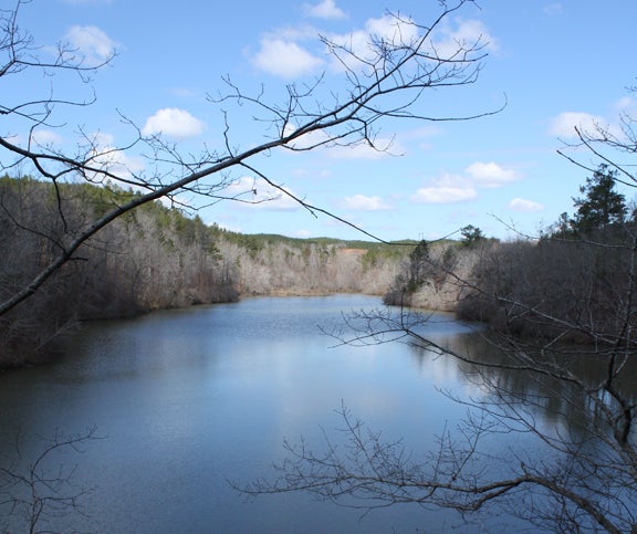
MITCHELL LAKE (pictured on the left)
5,850-acre impoundment on the Coosa River with 147 miles of shoreline.
PINHOTI TRAIL
alpta.org
WIND CREEK STATE PARK
alapark.com/parks/wind-creek-state-park
CHEAHA STATE PARK
alapark.com/parks/cheaha-state-park
ALABAMA HIKING TRAIL SOCIETY
hikealabama.org